The Big Picture
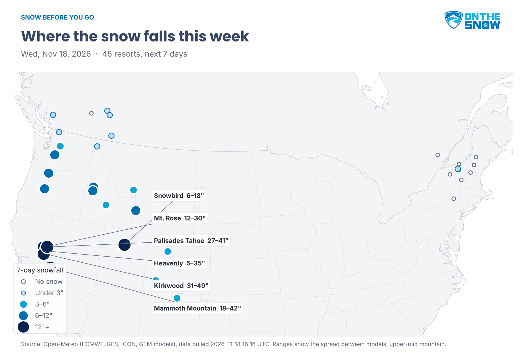
The Sierra storm is here, and it stays through Thursday. Today and Thursday are powder days at Kirkwood, Palisades Tahoe, Mammoth Mountain, Heavenly and Mt. Rose, and Kirkwood is on track for at least 2½ feet over seven days, with the snowiest models near 4 feet. The storm moves into Utah Thursday and Friday, with a powder day Friday at Alta, Snowbird and Solitude and 7–16 inches on the week. Idaho, Jackson Hole and Wolf Creek pick up useful snow, the rest of Colorado stays light and windy, and the Northeast stays dry until a cold front Monday.
Circle Thursday at Palisades Tahoe, Mt. Rose and Mt. Hood Meadows, Friday at Kirkwood, Mammoth Mountain, Heavenly, Tamarack, Brundage and Sun Valley, and Saturday at Alta, Snowbird, Solitude, Deer Valley and Park City.
Pacific Northwest
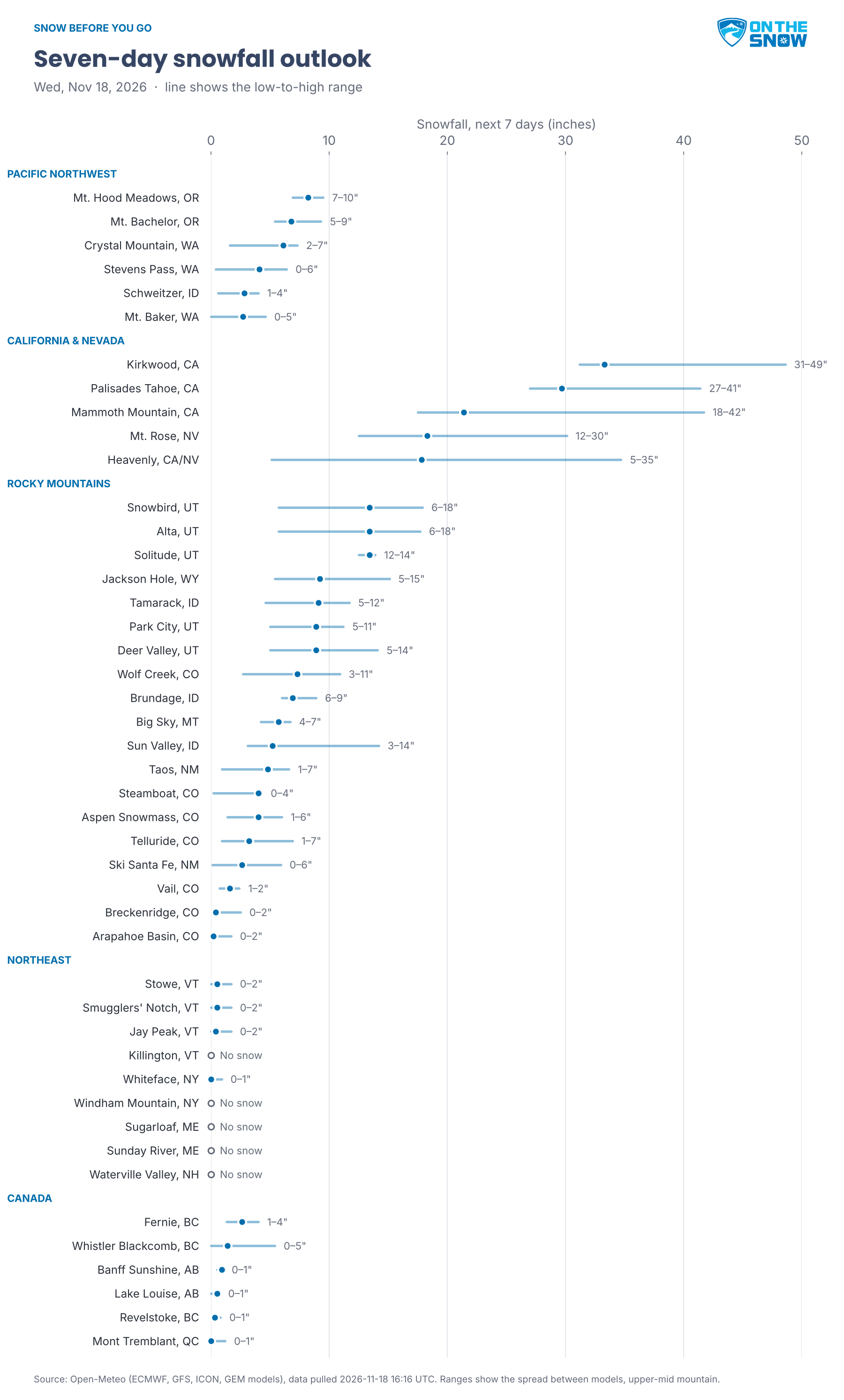
The Northwest catches the north edge of the storm today, then waits for the next round. Mt. Hood Meadows gets 2–5 inches today and 8–9 on the week, and Thursday is its day to ski, after today’s gusts in the 30s, with one model near 60. Mt. Bachelor picks up 2–4 inches today, 6–9 in all, with gusts near 40 and one model above 50, so upper lifts could hold. Crystal Mountain gets 1–2 inches today and 3–7 on the week, Stevens Pass 3–6, both with more Tuesday. Schweitzer and Mt. Baker see up to 4–5 inches. Highs stay in the mid-20s to low 30s, cold enough for snow at the top.
California & Nevada
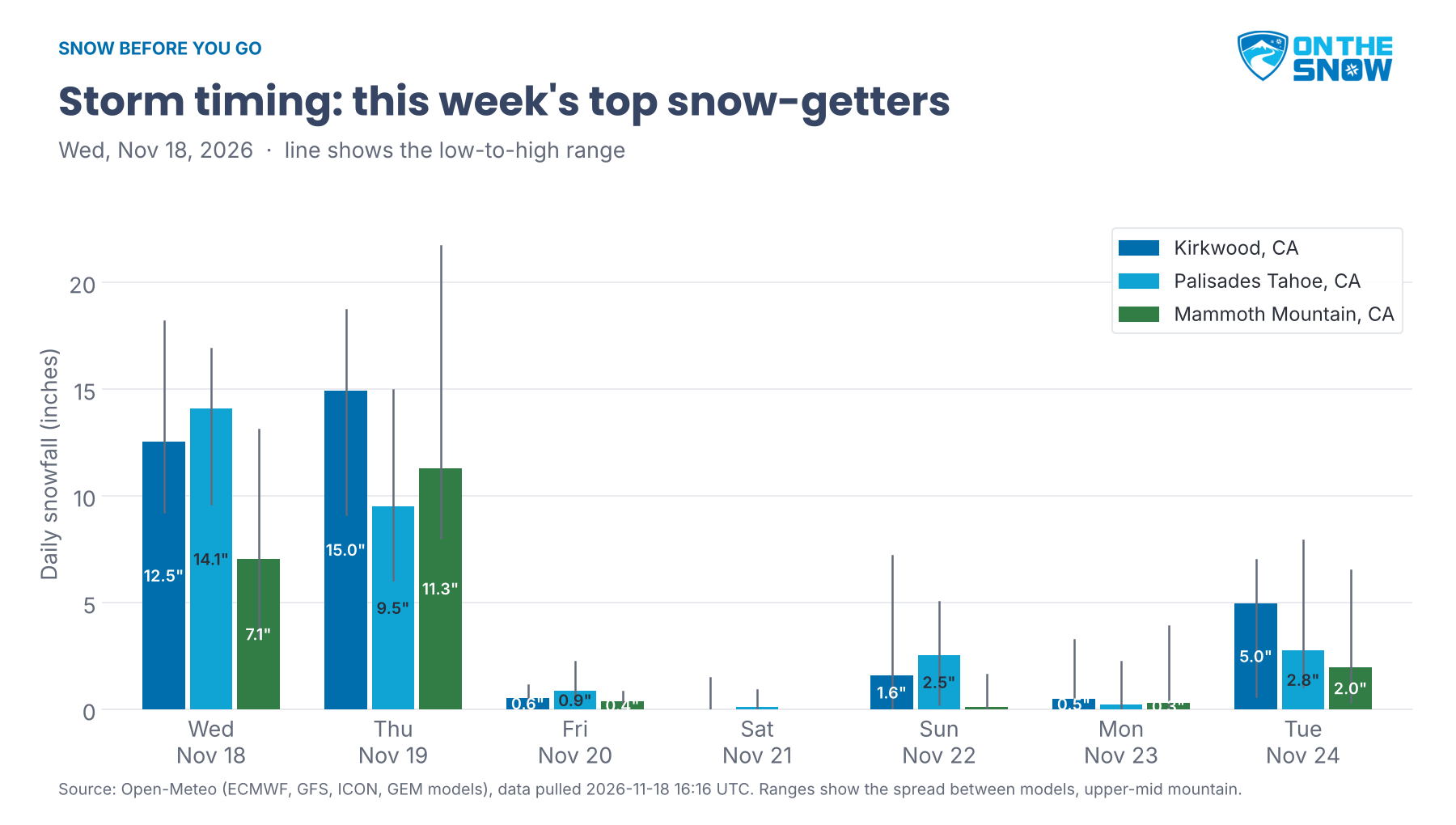
The storm’s two heavy days are today and Thursday. Today brings 10–16 inches to Kirkwood and 11–15 to Palisades Tahoe, 7–8 to Heavenly and Mt. Rose and about 6 to Mammoth Mountain, with the wettest models near a foot at Heavenly and Mammoth Mountain and 14 inches at Mt. Rose. Thursday adds about a foot at Kirkwood and Mammoth Mountain, with the snowiest models near 18 and 22 inches, about 9 at Palisades Tahoe and 7–8 at Heavenly and Mt. Rose. Wind is the catch: gusts in the 50s and 60s today at Kirkwood, Heavenly and Mt. Rose, with one model near 80 at Kirkwood, and one model brings Thursday’s gusts at Mammoth Mountain above 90, so expect lift holds. Thursday is the day at Palisades Tahoe and Mt. Rose; Friday, calmer and cold, is the day at Kirkwood, Mammoth Mountain and Heavenly, with lows near zero at Mammoth Mountain Friday and Saturday. Weekly totals: Kirkwood 30–46 inches, Palisades Tahoe 27–41, Mammoth Mountain 15–40, and Mt. Rose and Heavenly uncertain, from under a foot to about 3 feet. A few more inches fall Sunday and Tuesday, when some models bring rain to Palisades Tahoe.
Rocky Mountains
Colorado: Wolf Creek leads Colorado with up to 4 inches today and 1–5 Friday, 3–10 on the week, but gusts in the 30s to 50s, with one model near 70 Thursday and Friday, mean likely lift holds. Telluride gets up to 3 inches Friday and again Saturday, 1–7 in all, with gusts near 50 Thursday and Friday. Aspen Snowmass picks up 1–7 inches, mostly Friday and Saturday, with gusts in the 40s and one model near 75 Friday. Steamboat gets up to 6, Vail 1–4, and Breckenridge and Arapahoe Basin up to 2–4, with gusts in the 50s at both Friday. Thursday is mild, highs near 40 to the low 40s, before a cold Saturday with lows near zero.
Southern Rockies: Taos gets 1–3 inches today and 1–7 on the week, and Ski Santa Fe up to 3, mostly today. Wind is the bigger story: gusts in the 30s and 40s most days, with one model near 70 at Taos today and Friday and at Ski Santa Fe Saturday, so expect lift holds.
Utah & Northern Rockies: The storm reaches the Cottonwoods Thursday. Alta, Snowbird and Solitude get 1–7 inches Thursday and 3–8 Friday, their powder day, for 7–16 inches on the week at Alta and Snowbird and 13–15 at Solitude. Gusts run in the 30s and 40s both days. Saturday is the day at all three, cold and calmer, with highs near 20. Deer Valley and Park City get 2–9 inches Thursday and 3–6 Friday, 6–16 in all, also best Saturday. In Idaho, Tamarack picks up about 5 inches Thursday and 3–11 on the week, and Brundage 4–10, both best Friday. Sun Valley’s Thursday snow is uncertain, anywhere from 3 inches to a foot, also best Friday. Jackson Hole gets 6–13 inches, mostly Thursday and Friday, with gusts in the 30s and one model in the 50s today. Big Sky gets 4–6, with highs in the upper teens this weekend.
Northeast
The Northeast stays dry and mild through Sunday. Smugglers’ Notch, Stowe, Jay Peak and Killington in Vermont, Waterville Valley in New Hampshire, Windham Mountain and Whiteface in New York, and Sugarloaf and Sunday River in Maine see no snow, with highs in the upper 40s and low 50s and the mid-50s at Windham Mountain. A cold front Monday brings rain, up to an inch at Sunday River, and gusts that one model puts near 70 at Sugarloaf and Sunday River Monday and Tuesday. Behind it, highs drop to the mid-20s Tuesday with lows near 10 by Wednesday, the first real snowmaking cold of the week. Northern Vermont could see up to 2 inches.
Canada
Western Canada stays quiet and turns frigid. Banff Sunshine gets about an inch today, and Lake Louise up to an inch on the week, with highs in the mid-teens and lows below zero from Friday through Tuesday. Fernie picks up 1–4 inches, most of it Sunday. Whistler Blackcomb gets up to 5 inches, most of it Tuesday, and Revelstoke up to an inch. Mont Tremblant stays dry, with highs in the mid-40s, a little rain Monday and highs near 20 Tuesday.
Looking Ahead
Snow returns to the Cascades for Thanksgiving: Mt. Baker could get a powder day next Thursday, and Crystal Mountain, Stevens Pass and Whistler Blackcomb pick up a few more inches, with some rain mixed in. Kirkwood may see another powder day next Wednesday, but the next Sierra system looks warmer, with rain possible at Palisades Tahoe, Heavenly and Mt. Rose. The Northeast stays cold, with a chance of a few inches at Killington and Windham Mountain next Thursday. Confidence is low this far out.
Forecast data: Open-Meteo (ECMWF, GFS, ICON and GEM models), pulled Nov. 18, 2026, 12:42 UTC (Wednesday morning Mountain time), at upper-mid mountain elevation for each resort. Snow ranges show the spread between the four models; where they disagree widely, the text says so.